
Page 25 - Issue 74 Online
P. 25
MANEA MATTERS
MANEA MATTERS
COUNCIL UPDATE
have better access to jobs, education and leisure Councillors will shortly be focusing on preparing
activities within the county and beyond. for Winter and we will be reviewing the Manea
We are pleased to announce that we have Emergency Plan so we are prepared to provide
a new volunteer Speedwatch Co-ordinator
and hope that this will result in the re-start Councillors will shortly be focusing on
of the Speedwatch sessions. Please contact preparing for Winter and we will be
Peter Flack 07927 064677 if you would like to reviewing the Manea Emergency Plan
volunteer.
support and advice to residents in the event of
adverse weather events, flooding or prolonged
power cuts. Please do take the time to ensure
that you have access to basic emergency
equipment and if you have previously, or are
Other good news is that Cambs County Council worried about flooding, take the time now to
have recruited a ‘Crossing Assistant’ and look at what you can do to protect yourself and
hopefully they will be in situ soon after the new your property.
school year commences. This position has been A good starting point is the Be Flood Ready
funded by Manea Parish Council after hearing Website https://www.befloodready.uk/
parents/guardians concerns about the safety of
children arriving and leaving school. Lisa Eves, Chair
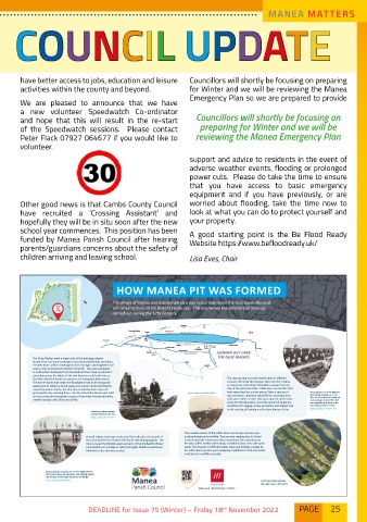
HOW MANEA PIT WAS FORMED
25
The village of Manea was established on a clay island that raised the land above the peat
PICNIC AREA soil covering most of the fenland landscape. This was before the widespread drainage
carried out during the 17th Century.
Littleport
Ely
Downham Market Denver WWT Welney
Salters
Kings Lynn Lode Earith
Welney Welches Sutton Gault
Three Holes Bridge Purls Dam St. Ives
Christchurch MANEA
Outwell LOOKING OUT OVER
Upwell
The Ouse Washes were a major part of the drainage scheme THE OUSE WASHES
designed by Cornelius Vermuyden that formed washlands extending March
19 miles from Earith in Huntingdonshire, through Cambridgeshire and Benwick
nearly as far as Downham Market in Norfolk. They were designed
to hold winter floodwater from the Bedford River Ouse to prevent it
spreading across the whole of the low-lying fens until such time as
the tides allow the water to escape to sea during low tide periods. The clay was dug out over several years in different
The barrier banks that retain the floodwaters had to be strong and sessions. We know this because there are the remains
waterproof to stand up to the waves and erosion inside the Washes of numerous coffer dams still visible running from one
caused by winter storms. For that they needed to have a layer of side of the pit to the other. Coffer dams are barriers that
good quality clay covering them. The clay island that Manea was built Photo courtesy of Stephen Short. hold water back for a short period. After a session of These photos are of the Bedford
River being cleaned out of silt.
on was a close and convenient source of clay when the barrier banks clay extraction, rainwater would fill the excavated area This was done by hand, using the
needed raising in the 1930s and 1940s. with water. When further clay was required, rather than same process as when the river
pump the flooded water out of the whole pit to get dry was originally dug. Most of the
conditions for digging, a new excavation was started next men were prisoners of war.
to the existing pit leaving a coffer dam barrier of clay. Photo courtesy of Stephen Short.
A stationary steam engine
used at the pit extract clay.
Photo courtesy of Peter Short.
The eroded remains of the coffer dams can be seen and are now
A small railway track was constructed from the pit to the banks of a valuable feature for wildlife. They provide nesting sites for Great
the Ouse Washes to transport the clay in side-tipping wagons. The Crested and Little Grebes and other waterfowl. The vegetation on
track crossed the Middle Level Low bank of the Old Bedford River/ the dams offers shelter when windy conditions blow across the open
Counterdrain on a bridge to reach the higher Middle Level Barrier water. The diversity of different water areas and habitats created by
Bank where the clay was needed. the coffer dams provide good spawning conditions for fish and varied
conditions for wildlife generally.
Bank workmen returning across the bridge over the
Old Bedford River/Counterdrain. Side tipping wagons
can be seen on the tracks that cross the bridge.
Photo courtesy of Peter Short. Aerial view clearly showing
the coffer dams in Manea Pit.
MANUALS • ECONOMICS • TRICKS
25
25
DEADLINE for Issue 75 (Winter) – Friday 18 November 2022 PAGE 25
th